

Area 2: Ecosystems


A small island is an understandable, albeit complex, mixture of ecosystems. Organisms from terrestrial and aquatic environments form the biotic, living part of an island’s ecosystem. Together with the abiotic, non-living parts – such as the geological landscape, the soil texture, and the weather conditions – the specific context for an island in question is formed.
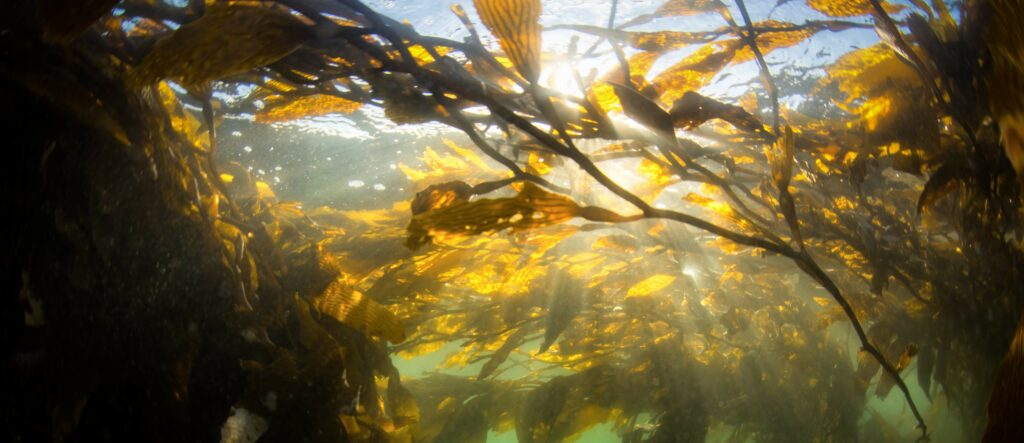
There are no size limits for ecosystems. They can be as small as a pike’s mouth or as big as the kelp forest in the Irish Sea. An island ecosystem is usually considered either small or medium scale. The whole surface of the Earth is a series of connected ecosystems, also called the biosphere.
A strategy called the ecosystem approach has been established to conserve and use ecosystem resources sustainably. The ecosystem approach is a strategy for the integrated management of land, water, and living resources. Humans are dependent on the goods and services produced by the environment. These are referred to as ecosystem services. Many of these services are taken for granted, like photosynthesis, natural air purification, and the circulation of nutrients in ecosystems. Mismanagement of these services will have negative consequences for humankind.
For islands, wherever they are located, ecosystem services significantly impact habitability; it is all about the fish in the sea, the crops in the fields, the timber in the woods, the bees for pollination. The beauty and allure of an island are also linked to ecosystem services. However, the shorelines of all the world’s islands attract hundreds of millions of tourists every year, putting high pressure on the environment.
References
- CBD. 2000. Sustaining Life on Earth. Secretariat of the Convention of Biological Diversity, 20 pp. (PDF) (2021/10/11).
- Lazrus, H., 2012. Sea Change: Island Communities and Climate Change. Ann. Rev.Anthro. 41:285-301.
Indicators in the Ecosystems area:
- (9) Land and sea area
- (10) Ecosystems at sea
- (11) Ecosystems on land
- (12) Storms
- (13) Climate Change
Indicator 9: Land and sea area
a) Rationale
An island is a piece of land surrounded by water. The so-called dry area is the area of an island primarily situated over the water’s surface; the tidal zone lies in the transition area between the land and sea. However, the aquatic area hosts an integral part of an island’s ecosystem and plays an essential role in analysing its habitability. Without water, the identity of an island is lost. If we limit habitability analysis to only the dry area, we will miss a crucial part of its richness and restrictions.
This is an intriguing indicator, as it can be challenging to define the amount of sea area that belongs to a particular island. The area depends on the island’s legal status, vicinity to the mainland, military importance, marine assets, and the like. Generally, an island has at least some jurisdiction over its surrounding sea. Usually, it is a place for more or less active national and regional monitoring and actions.
b) Definition
The area of an island is the area that belongs to the island and creates its identity, both on land and at sea. If the island lacks jurisdiction over the sea, the sea area is the surrounding water that, for natural, economic, and historical reasons, are connected to the life of the island.
The definition should be given in km2 along with a map. If the jurisdiction is unclear, the indicator calls for a joint judgment from a knowledgeable group of people.
c) Computation
Area in km2 and a map where special areas of interest and influence are identified, such as fishing, marine traffic, recreation/tourism, ancient memories, and natural resources (gas, oil, wind parks, and the like).
d) Example
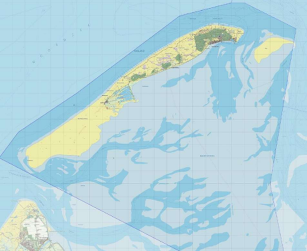
Vlieland, a Frisian island belonging to the Netherlands, is a municipality with 1,126 residents and an area of 316 km², 40 km² of which is land, and the remaining 276 km², water. The shallow water between Vlieland and the mainland is part of the Wadden Sea, a great asset and a Unesco World Heritage. Approximately 130,000 yearly visitors stay on the island for 4-4.5 days to appreciate the marine landscape. Consequently, mapping Vlieland should depict both the wet and dry areas and could also include Natura 2000 areas, existing and planned wind farms, routes for cables and pipelines, military sites, and shipping paths, as seen in the Netherlands Frisian Islands Marine Spatial Plan 2016–2021.
Indicator 10: Ecosystems at sea
a) Rationale
The UN Sustainable Development Goal-14 is named “Life below water”. To quote the UN, we should “conserve and sustainably use the oceans, seas, and marine resources for sustainable development”.
Our seas and oceans are under severe threats and risks, from eutrophication and acidification to overfishing, marine pollution, and ocean warming. About half of the marine key biodiversity areas are not under protection, and oxygen depletion in the bottom areas is causing dead zones, so-called marine deserts. Much of the richness and attractiveness of an island – for both residents and visitors – is related to the environments on and below the water surface.
b) Definition
The overall state of the ecosystems in the surrounding sea area.
c) Computation
The computation can be done in two different ways.
i) Do an assessment according to the state of the keystone species in the waters of your island, or ii) Follow the official status of the surface water surrounding your island, according to the EU Water Framework Directive. The EU Water Framework Directive aims to achieve a good qualitative and quantitative status for all water bodies. The directive includes inland water and marine waters up to one nautical mile from shore.
i) If your island makes or calculates its own computation, here is our advice. List the important keystone species in the surrounding water areas – about 10-15. Try to find a representative mixture of long-living algae, underwater plants, bottom-living invertebrates, important fish species, mammals, and seabirds. Give a value for the current state of each of these species from 1 to 4 according to the following computation:
- 4) High status: The species is healthy and in good condition. The species is present in the same amount and numbers as 20-40 years ago. The species does not seem to be harmed by the presence of humans.
- 3) Good status: The species is in good condition, and the numbers are more or less comparable with the situation 20-40 years ago. However, human presence has slightly influenced the living conditions of the species.
- 2) Satisfactory status: The living conditions for the species have deteriorated compared with the situation 20-40 years ago. The species number has decreased, and the spread is more scattered.
- 1) Bad status: The species has clearly diminished in numbers and presence compared with the situation 20-40 years ago. In extreme cases, the species has gone extinct.
The values can be collected by the islanders themselves or be based on scientific research reports, or both. Also, consider the present state compared to the situation, e.g. 20-40 years ago.
It is very appropriate to use citizen science – that is, what the islanders themselves can observe and document. This is a crucial part of the habitability work. There is a great deal of knowledge to be gained from fishermen, hunters and ornithologists. When the observations are done in collaboration with researchers, large data sets can be made reliable and structured.
The value should be motivated but can be based on scientific research reports, a questionnaire distributed to the islanders, or both. Also, consider the present state compared to the situation, e.g. 20-40 years ago.
When every species on the list has got an individual value, calculate the average of all the species, and use that number for indicator 10 of your island.
ii) If you choose to use the result of the EU Water Framework Directive (EU WFD), do the following: search for an official management plan where your water area is included; it should be found on the website of your local or regional environmental authority.
The ecological and chemical status of the surface water is assessed according to the regulation of the EU WFD. The directive is assessed due to the biological quality (fish, benthic invertebrates and aquatic flora), the hydromorphological quality (structure of river banks, substrate of river beds etc.), the physical and chemical quality (temperature, oxygen, nutrients), as well as the chemical quality of specific pollutants.
The EU WFD consists of five classes: very good, good, moderate, poor, and bad. As our Habitability assessment only has four values, both WFD classes moderate and poor correspond to Habitability value 2.
| 1 | 2 | 3 | 4 |
| The ecological status of the sea ecosystems is bad. The important keystone species have decreased in numbers or even disappeared.
EU WFD: bad | The ecological status of the sea ecosystems is satisfactory. The negative impact of humans is clearly seen.
EU WFD: moderate and poor | The ecological status of the sea ecosystems is good. However, a slight impact of human pressure is seen.
EU WFD: good | The ecological status of the sea ecosystems is high. The system is healthy and seems to be unaffected by human pressure.
EU WFD: very good |
d) Example
Kökar is part of the Åland Islands, an autonomous part of Finland. It is situated far out in the Northern Baltic Sea, between the main island of Åland and the Finnish mainland. The area is 2,165 km2 in total, where the dry parts are 64 km2 and the rest, wet areas, is 2,101 km2. Several large bays with hundreds of islets and skerries spread around Kökar add to the total area.
The overall state of the brackish Baltic Sea is classified as severe because of eutrophication and the biodiversity status, as well as contamination. There are signs of improvement during the latest years, but reaching a good ecological status is still far in the future.
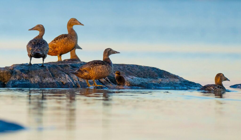
Seabirds have traditionally been an important part of the ecosystem services at Kökar. Historically, seabirds were an essential food resource in the archipelago. However, the occurrence of eider and other seabirds has decreased over several decades. Today, the causes are primarily the predation of eagles, but other factors can also come into question (Fazer, 2021). Moreover, Kökar is a hotspot for birdwatchers.
Fish and fishing have traditionally been important for the habitants of Kökar, both as food and for income. Still, it is of great importance to the habitability of the island. Research reports show declining stocks, e.g. in 2005; the catches were a third of the situation in 1996. At present, there is no commercial fishing on Kökar.
The brown algae bladderwrack (Fucus vesiculosus) and the aquatic plant eelgrass (Zostera marina) are key species for the shallow ecosystems of the Northern Baltic Sea. Therefore, they are valuable indicators of good status in marine habitats. In the Baltic Sea, the bladderwrack occurs down to 12 meters depths if the water is clear enough and if the turbidity caused by eutrophication is not hindering light from penetrating the water column. Eelgrass has a depth range of 2–6 meters and is found on exposed sandy bottoms. Both species are important nursing grounds for fish and invertebrates. Many ecosystems absorb and store vast amounts of carbon dioxide. The eelgrass in the Northern Baltic Sea is one of these efficient natural carbon storage sources.
On Kökar, a workshop was arranged with islanders who work in the fishing sector (fishermen, fish farmers, fishing guides) or who have interests related to fishing (anglers, hunters, people interested in nature and the local culture, etc.) and who therefore have knowledge about stocks, the marine environment, social values, cultural heritage, economic conditions and ecologically important areas.
Thirteen species in the aquatic nature of Kökar are listed. The total sum of the assessed indicator values divided by 13 gives the common indicator value:
| Keystone species | Ecological status in a long term perspective (approx. 20-40 years) | Assessed indicator value (1-4) |
| Seabirds | ||
| Eider (Somateria mollissima) | Decreasing | 1 |
| Common Golden-eye (Bucephala clangula) | Decreasing | 2 |
| Goosander (Mergus merganserser) | Increasing | 2 |
| Mute swan (Cygnus olor) | Increasing | 3 |
| Cormorant (Phalacrocorax carbo) | Increasing | 4 |
| Velvet scoter (Melanitta fusca) | Increasing | 3 |
| Sea eagle (Haliaeetus albicilla) | Increasing | 4 |
| Fish | ||
| Pike (Esox lucius) | Stable? | 2 |
| Perch (Perca fluviatilis) | Decreasing | 1 |
| Common whitefish (Coregonus lavaretus) | Decreasing | 1 |
| Baltic herring (Clupea harengus membras) | Decreasing | 1 |
| Underwater plant | ||
| Eelgrass (Zostera manrina) | Decreasing | 2 |
| Macroalgae | ||
| Bladderwrack (Fucus vesiculosus) | Decreasing in some localities, increasing in others | 2 |
| Sum | 28 | |
According to scientific reports and the judgment of islanders, the average value is 28/13= 2,15. This means that the Habitability indicator value 10 for Kökar is 2, on a satisfactory level. The EU WFD of the surface water places almost all waters of Åland Island to the state moderate, also corresponding to the Habitability class 2.
References
- EC. 2020. The State of Nature in the EU. European Union publications, 40 pp. Opens in PDF-format. (2022/03/21).
- EC. 2022. Habitats directive reporting. (2022/03/21).
- HELCOM, 2018. State of the Baltic Sea – Second HELCOM holistic assessment 2011-2016. Baltic Sea Environment Proceedings 155, 155 pp (2021/10/12).
- Röhr, E, Holmer, M, Baum, JK, Björk, M, Boyer, K, Chin, D, Chalifour, L, Cimon, S, Cusson, M, Dahl, M, Deyanova, D, Duffy, JE, Eklöf, JS, Geyer, JK, Griffin, JN, Gullström, M, Hereu, CM, Hori, M, Hovel, KA, Hughes, AR. & 17 others. 2018, Blue carbon storage capacity of temperate eelgrass (Zostera marina) meadows. In: Global Biogeochemical Cycles. 32, 10, p. 1457–1475.
- Nygård, H. 2005. Fisksamhällets tillstånd på Kökar, SE Åland. Forskningsrapport nr 114 från Åbo Akademi, Husö biologiska station, 38 pp (in Swedish with an English abstract).
- Fazer, O., 2021. Ejderstammens utveckling på Yttre Klåvskär. Examensarbete för Agrolog (YH)-examen, Yrkeshögskolan Novia, 18 pp (in Swedish with an English abstract).
- EEA, 2019. Marine messages II. Navigating the course towards clean, healthy and productive seas through implementation of an ecosystem‑based approach. European Environmental Agency, EEA Report No 17/2019, 82 pp. (2022/02/21).
- EC, 2022. Introduction to the EU Water Framework Directive. European Commission.
- Åland.ax, 2020. The surface water status on the Åland Islands 2012-2018. Opens in PDF-format.
Indicator 11: Ecosystems on land
a) Rationale
The land-based ecosystems on an island are the same as a mainland, such as forests, lakes, and meadows. The ecosystems on the shorelines to the sea are also important for an island. These ecosystems can be exposed rocks, low-lying coastal meadows, as well as beaches of sand or larger stones. The island landscape and its biodiversity are strongly formed by the soil composition, the weather conditions and the close connection to the sea.
Within the EU, the ecological state of the ecosystems is regulated by the Habitat and the Bird Directives. These directives aim to protect a combined 233 distinct habitat types, 1400 rare, endangered or vulnerable species, and the 460 wild bird species of Europe.
b) Definition
The present state of the key habitats and species – wild species of vertebrates, invertebrates, plants and birds – compared to the situation 20–40 years ago. If an ecological field study has recently been conducted on your island, use that data. Otherwise, make your own list and use your own judgments.
c) Computation
Make a list with the following data:
- Natural and semi-natural habitats (habitats with no or slight human impact on biodiversity and biological processes) typical for the island.
- Wild species, typical for the island, sorted by the following categories:
- vascular plants: 5-10 species.
- mammals: at least five species.
- invertebrates: choose species that are also easy for non-biologists to recognise, such as butterflies, bees, beetles etc.: 5-10 species.
- birds: try to pick both breeding and wintering species: about ten species.
Give a value, between 1 and 4, to all these species and habitat types according to the following:
- 4) High status – The species is healthy, and in good condition; the habitat is favourable and stable. The species is present in the same amount or increasing as 20-40 years ago. The species seems not to be harmed by the presence of humans. The habitat is sufficiently large to ensure continuous maintenance of the species on a long term basis.
- 3) Good status – The species is in good condition, and the numbers are more or less comparable with the situation 20-40 years ago. However, human influence has slightly influenced the living conditions of the species. The habitat is sufficiently large to ensure continuous maintenance of naturally occurring species, but actual or potential negative influencing factors may have an impact.
- 2) Satisfactory status – The living conditions for the species have deteriorated compared with the situation 20-40 years ago. The species number has decreased, and the spread is more scattered. The habitat is not sufficiently large to ensure a continuous natural occurring species.
- 1) Bad status – The species has clearly diminished in numbers and presence compared with the situation 20-40 years ago. In extreme cases, the species has gone extinct. The habitat is heavily impacted by human influences, has declined in size, and is no longer in a natural condition.
The value should be motivated but can be based on either scientific research reports, a questionnaire distributed to the islanders, or a combination of both. Also, try to consider the present state compared to the situation, e.g. 20-40 years ago.
When you have evaluated all species and habitats listed in categories 1-4, calculate the average, which will be your value for indicator 12.
| 1 | 2 | 3 | 4 |
| The land ecosystems are in a poor or bad state | The land ecosystems are in a satisfactory state | The land ecosystems are in a good state | The land ecosystems are in a high and stable state |
d) Example
The island Jurmo is 2.79 km2 in size (5 km x 1 km).
The island is part of the city of Pargas in Southwest Finland. By car (about 35-40 minutes driving time), one ferry (10 minutes + eventual waiting time), and the connecting boat (3-3.5 hours), the perceived distance from the centre of Pargas to the harbour of Jurmo is considerable; especially since there are fewer departures for the connecting boat and not even daily ones during the winter season.
The nature of Jurmo is exceptional, and it differs greatly from the islands nearby. The island is an extension of the Salpausselkä ridge, which is a remnant of the last Ice Age. The terrain on Jurmo is barren and stony. Jurmo is a Natura 2000 area and part of the Archipelago Sea National Park. The island’s nature is well investigated; for example, ornithological observations date back from the 1960s onwards.
Jurmo has about ten permanent inhabitants. However, the island attracts part-time residents and visitors throughout the year. Due to the fragile environment and nesting birds, visiting the western part of the island is prohibited from April to August.
The state of the land ecosystem on Jurmo is represented by three habitats and nine species. The total sum of the assessed values divided by 12 gives the common indicator value.
| Ecological status in a long term perspective | Indicator value (1-4) | |
| Habitat (natural/semi-natural) | ||
| Heath | Relatively stable. Due to restoration (clearing of land), the living conditions for the heather (Calluna vulgaris) have improved in a longtime perspective. | 2 |
| Grove | Stable | 2 |
| Coastal meadow | Stable. Dependent on the presence of cattle. Eutrophication may have had a negative impact. | 2 |
| Wild species | ||
| Vascular plants | ||
| Heath (Calluna vulgaris) | Stable. Fluctuating flowering. | 2 |
| Vertebrates | ||
| Mountain hare (Lepus timidus) | Strong fluctuations due to the availability of food and predation pressure. | 2 |
| Field vole (Microtus agrestis) | Strong fluctuations due to the availability of food and predation pressure. | 2 |
| Common frog (Rana temporaria) | Relatively stable. | 2 |
| Invertebrates | ||
| Rock grayling (Hipparchia semele) | Common and stable. Benefits of open areas. | 2 |
| Birds | ||
| Redshank (Tringa totanus) | Stable | 2 |
| Arctic tern (Sterna paradisaea) | Slightly increasing. However, the nesting sites have moved from the main island to nearby skerries. | 3 |
| Common eider (Somateria mollissima) | Strong decrease due to predation. More or less absent on the main island; 80-90% decrease on nearby skerries. | 1 |
| Southern dunlin (Calidris alpina schinzii) | Always in small numbers. 4-6 pairs in the 1990s, during the latest years 1-2 pairs (1 pair in 2021). No changes were observed despite active restoration (restored biotopes, diminishing predators such as fox). | 1 |
| Sum | 23 | |
According to a judgement based on long term nature conservation and bird watching, the average value is: 23/12= 1.92. This means that the Habitability indicator value 11 for Jurmo is 2, on a satisfactory level.
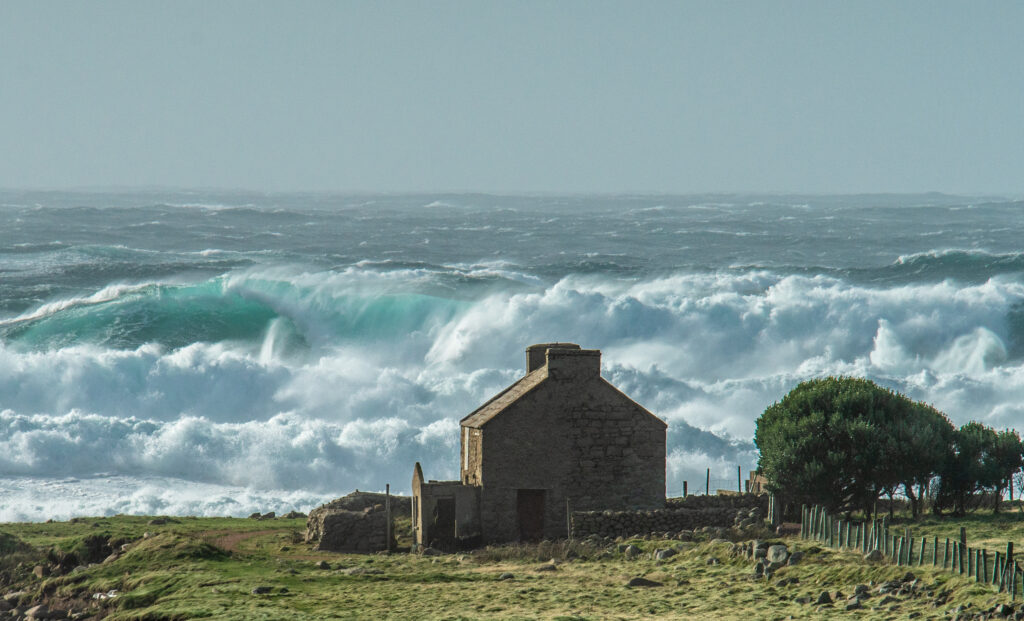
Indicator 12: Storms
a) Rationale
Bad weather – especially storms – has always determined the life of the islanders. This was the case long before climate change, even if a consequence of global warming is stronger and more frequent storms (IPCC 2021). Islands are vulnerable to storms, which can cause damage to infrastructure, interrupt communication and power, and cause human injury and loss of lives. Strong winds impact coastal erosion, decrease freshwater resources, cause effluent and sewage systems to overflow, and affect recreational facilities. Frequent and long power failures, and cancellations in the ferry traffic, are everyday problems for many islanders.
The definition of storms is wind speeds of more than 24.5 m/s (89 km/h, 55 mph).
b) Definition
The level of damage to buildings, infrastructure and services because of storms.
c) Computation
| 1 | 2 | 3 | 4 |
| Frequent disadvantages affecting daily life (more than 15 days a year), damage and high costs caused by storms. | Disadvantages affecting daily life (5-15 days a year) and high costs related to storms. | Some damage from storms, but society is well-prepared | None or almost no damage from storms |
d) Example
Tory Island, officially known by its Irish name Toraigh, is an island 14 kilometres off the North-West coast of County Donegal. It is Ireland’s most remote inhabited island.
The island is approximately 5 kilometres long and 1 kilometre wide. The 2016 census recorded a population of 119, a decrease from the 2011 population of 144. The population is distributed among four towns: An Baile Thoir (East Town), An Baile Thiar (West Town), An Lár (Middletown) and Úrbaile (Newtown).
The island of Tory has regular daily ferry connections to the mainland. The ferry, operating all year round, does not take cars but holds up to 70 passengers. Tory has no airport; however, a four-seater helicopter operates every other Thursday between Falcarragh and Tory between November and March. During the winter months, ferry crossings may not be possible due to rough seas or bad weather. The area is extremely tidal, and there are also days when the ferry can’t operate because of very low tides.
According to statistics provided by the Islands Unit at the Department of Rural and Community Development in the Irish Government, during the years 2019–2021, the planned crossings for the Tory ferry were 6,828. From these, 5,218 ferry sailings could be carried out according to plan. During these three years, the ferry was cancelled due to storms 736 times (11% of the planned sailings). In February 2020, only 74 ferry crossings out of the 174 planned could be carried out. Of these, 88 crossings were cancelled due to bad weather.
Highly exposed to the elements in the Atlantic, everyday life on Tory Island is often affected by storms, especially in the winter when the main lifeline to the mainland, the ferry, is often cancelled. Tory receives a score of 1.
References
- Populated off-shore islands. Published 2015, last updated 2020. Department of Rural and Community Development.
- Tory Ferry.
Indicator 13: Climate Change
a) Rationale
Climate risks are the combining result of climate-related hazards, vulnerability, and societal exposure. The main drivers of climate-related hazards include changes in temperature, precipitation intensity, windstorms, and sea-level rise. Also, factors such as salinity and water temperature are affected. These drivers are influenced by natural variability and anthropogenic climate change (Tuhkanen & Piirsalu, 2020).
The consequences for society are either direct or indirect. Hazards related to climate change will cause loss of life, injury or other health impacts, property damage, social and economic disruption, or environmental degradation (UN 2016).
When looking at the climatic changes and impacts in the whole of Europe, there is a considerable variation between the different biogeographic regions and within regions. Islands have an exposed position and face concrete risks due to a changing climate. Low-lying coastal regions and islands are vulnerable to sea-level rise; this includes a potential risk for flooding and coastal erosion. Another impact can be saltwater intrusion into low-lying aquifers, threatening water supplies. The loss of unique biodiversity on islands due to climate change would be huge.
Various impacts of climate change have consequences on the infrastructure, such as harbours, ferries, and airports, which will further cause potential impacts on tourism, recreation, and transportation functions. On many islands, agriculture is crucial for minimising dependence on food imports and is also an important source of foreign revenues. In the long term, most islands will be faced with decreased crop production and, at the same time, higher costs for water irrigation.
In the summer of 2021, the island of Sicily set a new European heat record of +48.8 °C.
b Definition
Assess the level of threats from climate change.
c Computation
Please see the map from the report, “Climate change, impacts and vulnerability in Europe 2016. An indicator-based report”. Use the list of climatic changes and impacts for your region, and also include changes and impacts for “Coastal zones and regional seas”. If the impacts for your region seem insufficient, please add more suitable impacts from other regions.
Give a value for the importance of these changes or impacts on your island. The value should be based on reliable observations by a considerable number of islanders, part-time islanders and regular visitors during a period of at least 20 years.
| 1 | 2 | 3 | 4 | X |
| Affecting island life | Considerable changes already notable | Minor changes already notable | No changes notable | Can not be applied to our island |
Click here to open a fillable PDF-form for the Climatic changes and impacts.
d Example

The Danish island of Strynø is a flat island, 3×2 kilometres in size, situated south of Fyn. The island population peaked in early 1900 with 800 people, when most of the male inhabitants were hired on the sailing ships belonging to the larger neighbour islands of Ærø and Thurø. Today, the island population is just over 200 persons.
The sea around the island is very shallow and creates a special habitat for shallow water vegetation, fish and birdlife, as well as a considerable amount of seals. The highest point of the island is nine metres above sea level. Strynø is situated in a bird sanctuary, and the shallow sea provides a rich food source. Large flocks of swans, geese and other migratory birds inhabit the island successively during the year. Fish stocks have decreased in the past few years. Eel was abundant in the past century but has nearly disappeared in modern times.
The weather greatly influences everyday life: here, the wind largely determines the high or low tide and is responsible for occasional flooding of the surrounding small islands and the coast of Strynø. As on other small islands, Strynø has more hours of sunshine in the summer than the mainland, as the landmass of the island is too small to attract and create clouds.
On the map, Strynø is situated in the green area, “Continental Region”. Because of the close vicinity to the North Sea, also the changes and impacts of the “Atlantic region” were added, in addition to those from “Coastal zones and regional seas”.
| Climatic changes and impacts | 1 | 2 | 3 | 4 | X |
| Continental region | |||||
| Increase in heat extremes | 2 | ||||
| Decrease in summer precipitation | 2 1) | ||||
| Increasing risk of (river) floods or sea-level rise | 3 | ||||
| Increasing risk of forest fires | No forest | ||||
| Decrease in the economic value of forests | No forest | ||||
| Increase in energy demand for cooling | 3 | ||||
| Coastal zones and regional seas | |||||
| Sea level rise | 3 | ||||
| Increase in sea surface temperatures | 4 | ||||
| Increase in ocean acidity | 4 | ||||
| Northward migration of marine species | Unknown | ||||
| Risks and some opportunities for fisheries | 2 2) | ||||
| Changes in phytoplankton communities | x | ||||
| Increasing number of marine dead zones | Unknown | ||||
| Increasing risk of water-borne diseases | 4 | ||||
| Atlantic region | |||||
| Increase in heavy precipitation events | 3 | ||||
| Increase in river flow | x | ||||
| Increasing risk of river and coastal flooding | 2 | ||||
| Increasing damage risk from winter storms | 1 | ||||
| Decrease in energy demand for heating | x 3) | ||||
| Increase in multiple climatic hazards | x | ||||
| Sum 33/12 = 2,8 | |||||
References
- Coastal Risk Screening Tool. (2021/11/05)
- EEA. 2017. Climate change, impacts and vulnerability in Europe 2016. An indicator based report. European Environment Agency, EEA Report 1/2017, 419 pp. (2021/11/12)
- EEA. 2021. Global and European Sea Level Rise. European Environment Agency. (2021/11/12)
- Tuhkanen & Piirsalu, 2020. Overview of climate risk drivers, hazards and consequences. Report published within the CASCADE project, 70 p. (PDF) (2021/11/12)

The Habitability Handbook – An assessment tool for viable island communities by the Archipelago Institute at Åbo Akademi University is licensed under Creative Commons Attribution-NonCommercial-NoDerivatives 4.0 International License.